Spatial and Temporal Change Assessment of Drainage Impacts on Agricultural Land Quantity
Client/Consultant Background and Project Goal

The Drainage Investment Group is a non-profit organization that secures funding to contribute to the quality of municipal drains and water quality.
The project goal was to conduct a spatial/temporal change assessment on agricultural land-use within the Point Abino watershed in Fort Erie and Port Colborne, Ontario. This analysis was done to help determine if the watershed's municipal drain has helped lead to any increase in agricultural land quantity. |

Geospatial Operations (Adam Tomlin) created a proposal, progress, and final report on the project with bi-weekly status updates throughout October 1, 2013 - June 13, 2014. A trial budget and earned-value management (EVM) was used to calculate the overall cost and efficiency of the project.
|
Major Methods of Analysis
• Research multispectral satellite imagery
• Research, scan, and georeference aerial imagery
• Conduct unsupervised and supervised satellite image classifications to distinguish vegetated areas
• Digitize agricultural land-use within georeferenced aerial images
• Research, scan, and georeference aerial imagery
• Conduct unsupervised and supervised satellite image classifications to distinguish vegetated areas
• Digitize agricultural land-use within georeferenced aerial images
The slideshow below displays some of the project's progress and final deliverables.
The work breakdown structure PDF file below can provide an overview of the allocated project tasks and resources that were available.
| Work Breakdown Structure and Costs |
Final Report
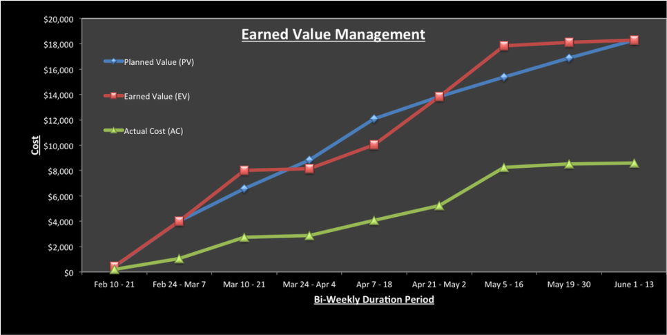
The graph below displays the earned-value management throughout the project's bi-weekly report periods.