|
In today's interconnected world, the utilization of data has become a driving force behind economic growth and development. Among the various types of data available, spatial data holds a unique position due to its ability to provide critical insights into geographic patterns and relationships. From urban planning and infrastructure development to market analysis and resource management, spatial data plays a vital role in fostering sustainable economic progress. Through professional projects and freelance contracting, I provide data transformation, visualization, and presentation services to a variety of clients and aim to present non-sensitive informative insights and professional portfolio pieces through articles, blog posts, and social media. I enjoy exploring the importance of spatial data in economic development and its transformative impact across various sectors. The Toronto Board of Trade plays a key role in the integration of municipal economic policies across the Toronto region. The aim is to optimize the Region's GDP and raise competitiveness to attract more investment. GIS brings a key component to the place-based value of land-use planning and employment zoning to ensure unintended policy consequences don't lead to residential urban sprawl and diminishing economic potential of unoptimized land. Pressure to convert Commercial and Industrial Employment Land to Residential are being seen across the GTA and GTHA, with cross-jurisdictional impacts going unrecognized. 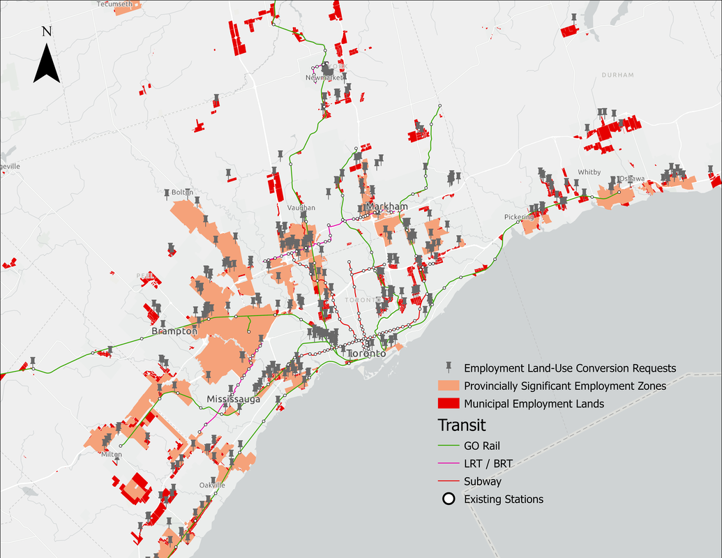 Residential land-use can produce unintended pressure to convert nearby industrial lands due to conflicting natures of activity. Quantitative Spatial Data for Qualitative InsightsThe story of conversion pressure within the economic zone surrounding Pearson International Airport contains a significant amount of travel concentration for employment. This is an example of how we can use pilot areas and quantitative data to derive valuable qualitative insights about the context behind cultural economies. 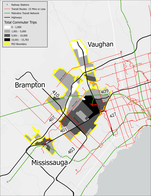 By analyzing quantitative data through a geographic lens, we begin to derive a qualitative story about the information. 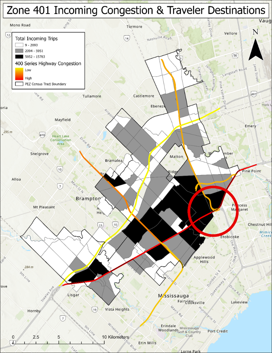 Combining spatial data layers to simultaneously analyze interconnected variables provides the value of seeing what others can't, giving your city a unique edge of cultural competitiveness in the modern global marketplace. GIS provides the insight into new age economic growth. Spatial data refers to information that links data points to specific geographic locations, enabling the analysis and interpretation of patterns, relationships, and trends within a given space. By integrating spatial data into decision-making processes, policymakers, businesses, and researchers can gain valuable insights to make informed choices and formulate effective strategies:
Challenges and Future DirectionsWhile the importance of spatial data in economic development is undeniable, there are challenges that need to be addressed for its optimal utilization:
Spatial data has emerged as a critical component of economic development strategies worldwide. Its ability to provide insights into spatial relationships, inform decision-making, optimize resource allocation, and support sustainable planning makes it an indispensable tool for governments, businesses, and researchers. By harnessing the power of spatial data, societies can unlock their full economic potential, build resilient cities, and create opportunities for inclusive growth. Embracing spatial data as a fundamental pillar of economic development will pave the way for a prosperous and sustainable future.
0 Comments
|
Archives
June 2023

|
 RSS Feed
