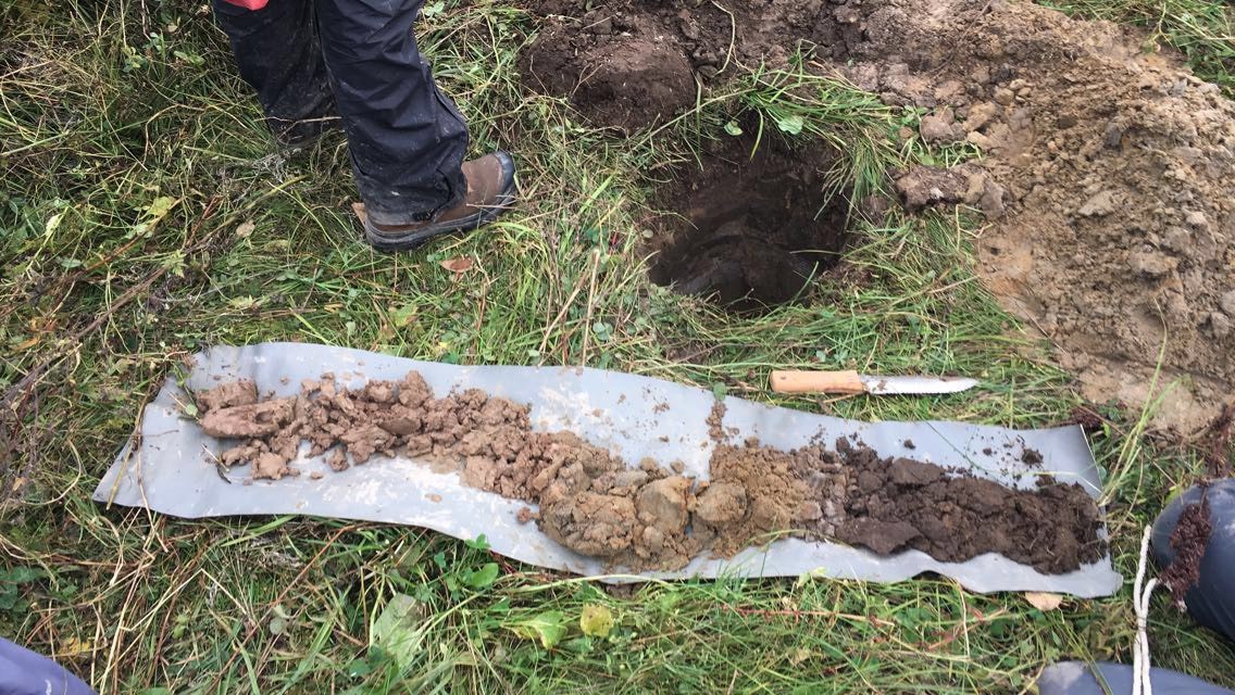
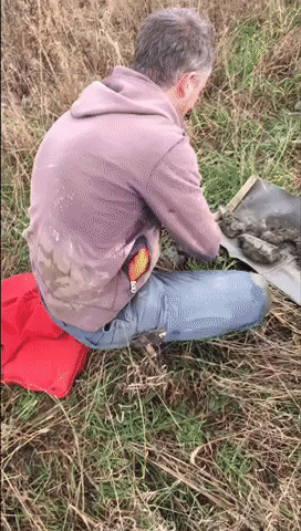
 The toughest part of anyone's career is the gap of time between graduating post-secondary school and entering the workforce. The first position after graduation is key for anyone in the GIS field to start building a professional network to learn from and help you build on your skills and experience. My first position was a GIS technician at the Ontario Ministry of Natural Resources in Peterborough, Ontario in 2016. Niagara College's Geospatial Management program was geared towards personal GIS business and consulting, whereas a lot of my colleagues at the Ministry of Natural Resources (MNRF) and the Ontario Ministry of Agriculture, Food, and Rural Affairs (OMAFRA), went to Flemming College, which was geared more towards government GIS applications. It was interesting to learn more about the different structures of work cultures in the public and private sectors, and how understanding this was going to be important for determining how my career would unfold. The big difference between GIS applications in the public and private sectors is the red tape involved in the development of new methodologies to innovate and get creative to pragmatically approach issues and conserve resources. Private sector employers would be more favorable to finding the fastest way to solve a problem, whereas public sector employers may rely more on "by the book" methods to preserve structure in the organization and conform to standards set out in various forms of legislation. The Ontario Ministry of Natural Resources and Forestry- Peterborough, Ontario 2016 - 2017 Spatial Data Infrastructure Support, Imagery Information Management, Southern Ontario Land Resource Information System The MNRF presented a multitude of options to create my own adventure in that short summer. There were times when I had to actively seek out the knowledge and skills necessary to continually make an impact and progress instead of wasting time with busy work I would sometimes get allocated towards under my contract. I jointly worked towards improving the spatial accuracy of 7500 watercourse features in the Ontario Hydrology Network (OHN), along with other public datasets like the Ontario Road Network (ORN) and the Ontario Imagery Program. 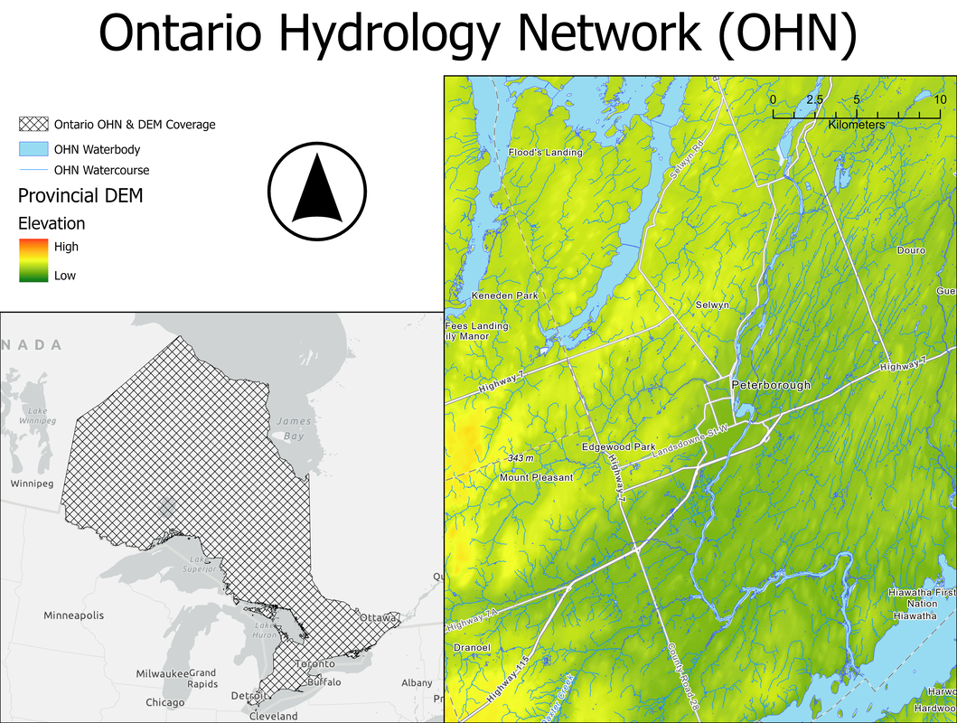   The information Management division allowed me to understand the spatial data life cycle for vector and raster data in conjunction with provincial legislation enforcing data quality standards and methodologies. I was in charge of documenting the business processing of the Digital Imagery Asset Management Ontario Database (DIAMOND) used for automating imagery project data organization for stakeholder delivery. The Southern Ontario Land Resource Information System I was offered a second contract working as a remote sensing analyst in the Forest Resource Inventory unit. We observed temporal NDVI difference composite imagery of the province to verify certain land-use changes through orthoimage interpretation.  We were on the verge of developing plans and standards for ecosystem mapping along Lake Erie, until... The Ontario Ministry of Agriculture, Food, and Rural Affairs - Guelph, Ontario - 2017 - 2018 Field Work, Project Management, Business Analysis The Ontario Ministry of Agriculture, Food, and Rural Affairs offered me an internship to work on updates to the Ontario Soil Survey Complex geodatabase updates. This required extensive field plans and project management. Our team devised our data collection plan between Peterborough County and Ottawa Region, in which we used ArcGIS Collector to record attributes for soil samples.
 Innovating Old Methodologies and Increasing the Quality & Value of Data Products with New Technologies We had created visuals and graphics of research methods used with new developments in geospatial technologies. Showcasing the innovation in the sector helped stakeholders in the province understand the value new geospatial technologies bring to the table and incentivized further investment in soil mapping initiatives. 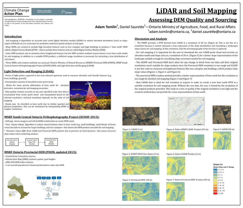 In office, we used Python to automate updates to soil polygon slope classifications based on DEM data derived from LiDAR surveys . 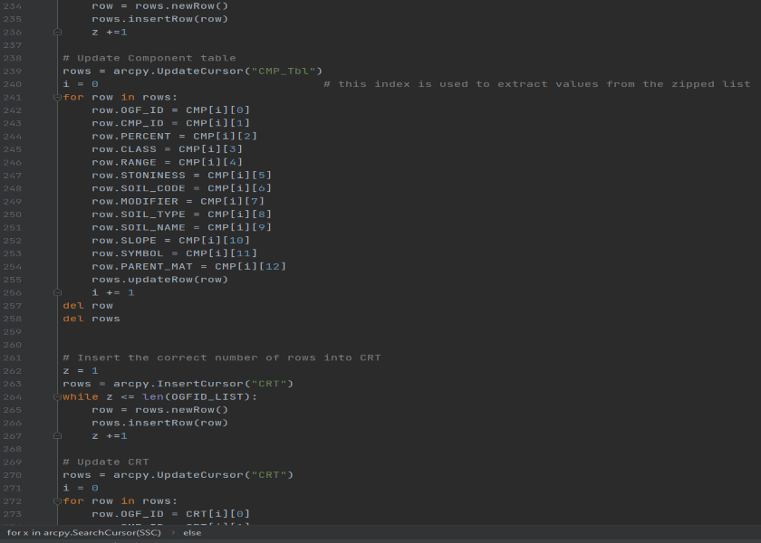 In addition to the soil mapping, the policy and planning division leveraged GIS to develop land-use plans for animal agriculture in northern Ontario. These public initiatives sparked an important development in the integration of geospatial technology towards a more digitally mature economy.
0 Comments
 How It Started I started to use my portfolio as a medium for showcasing my work in GIS as I finished my time at Niagara College and Brock University. Within the foundations of my experience and education in geography, I initially wanted to learn skills related to the assessment of public policy, urban planning, and social/cultural demography to help solve societal and economical issues damaging the efficiency of our modern day society. Through my degree, I then discovered geospatial technologies and the role they played in the practicality of urban planning and resource management. Together, with my research skills gained at Brock University, I have been growing my skills in geospatial data science and analysis. I started at the Ontario Ministry of Natural Resources, to then complete an Internship at the Ministry of Agriculture. Once I started working at Esri Canada in 2018 and moved to Toronto from Guelph, I started to build my knowledge on the entire scope of GIS in various job economic sectors and which one was the most sustainable to pursue long term.  How It's Going
By adding a blog component to the portfolio, I stay active amongst the geospatial community online while providing a space to archive new experiences and build reflections for improving upon old experiences. I enjoy the chance to connect and network with new members of the GIS community while learning new ways to integrate the niche's love of mapping into everyday life. It's interesting to understanding how to translate that value onto the public and hold interest within the spatial lens geospatial-minded people view the world. After completing degrees/diplomas in GIS and Geography, I felt blogging and social media was a good post-COVID world of networking to expand my experience in this field. As I get more involved in the social media aspect of things, I find myself wanting to combine creative and technical writing with copywriting and mapping for smaller businesses and entrepreneurs. There seems to be a gap of knowledge and applications in mapping technology and literacy when it comes to everyday users in contrast to professional users and bigger corporations. I wish to gear my skills towards a network of users that can benefit from mapping and data transformation products for their businesses.  The Big Picture
By starting work in government and bridging my skills over to Esri Canada as a GIS Consultant in 2018, I’ve developed a focus on using geospatial technologies with my background in geography, social science, and quantitative/qualitative research design and data analysis to contribute to the improvement of geospatial literacy in everyday life and help new businesses compete with the location analytics and market research advantages of larger competition. Data Provides Value and is an Asset in Today’s Economy In order to expand my skills and experience within the geomatics field and network to new members of the geospatial community, I offer and provide pro-bono low-cost services building geospatial data transformation products to help establish standardized methodologies for new businesses to optimize their resources and business models. I wish to build my portfolio and online presence to add value and enthusiasm to a field progressing to its full potential in the modern technological world. |
Archives
June 2023

|
 RSS Feed
