The Transition from Data Curation to Research Applications
Spatial Data Science and Exploring Decentralized Innovation for Economic Development: The case for Transit Planning and The Toronto Pearson Economic Zone Data Foundation Esri Canada was the next step from soil mapping with OMAFRA, which also laid the groundwork and foundation for building tools for applied research in the field of geographic analysis. I worked in the Community Maps program at Esri Canada from June, 2018 - September, 2022. This position allowed me to refine my GIS knowledge and skills with the world leader of GIS technology, while progressing in the art/science of data quality/assurance and curation for basemapping. I was able to learn more about technical blogging, presentations and demos through a variety of courses and projects working with internal and external clients. This eventually pushed me to do more pro-bono or low cost consulting and technical GIS work through my own individual proprietorship.  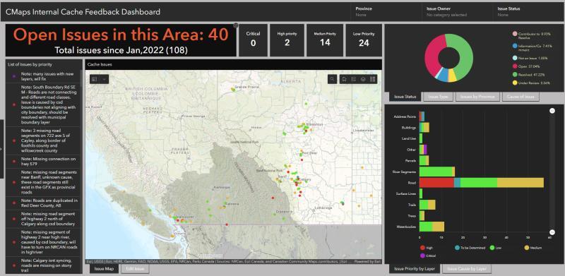 Data Development My experience at Esri and background in social science geographies created a good mix of creative and technical techniques for research and data analysis. The summer of 2022 led me to explore and complete the Google Data Analytics certificate through Coursera to add more mainstream data analytics techniques with software like R and Tableau onto my GIS analytics foundation. This eventually got me an offer for a Research and Planning Analyst position at the Toronto Region Board of Trade, working on research initiatives to help businesses in the Greater Toronto Hamilton Area (GTHA) take advantage of the economic heartbeat of the Pearson Toronto International Airport economic zone. Incorporating quantitative and qualitative spatial analytics techniques into the research of this zone will be a key component of the initiative's success. It will incorporate a multivariate array of information sources from urban planners and data scientists to communicate the economic importance to the masses and promote the importance of understanding the spatial context, interconnectedness and interdependence of economics in the area. Building Connections, Relationships, and Partnership to Enhance the Scope of our Knowledge and Growth as an Economic Region Community Maps at Esri Canada involved the creation of new relationships and partnerships with different public and private organizations providing data to enhance the quality of our basemaps for client's to utilize for support in their geospatial projects. My role at the Toronto Region Board of Trade incorporates this principle in the business relationships and partnerships the Board initiatives for economic development in the GTHA - while having a broader scope beyond basemap development with the same spatial concerns for data quality in mind. The development of spatial data literacy and analysis in the Pearson Economic Zone is an underlying and overlying asset to stakeholders in the long run. 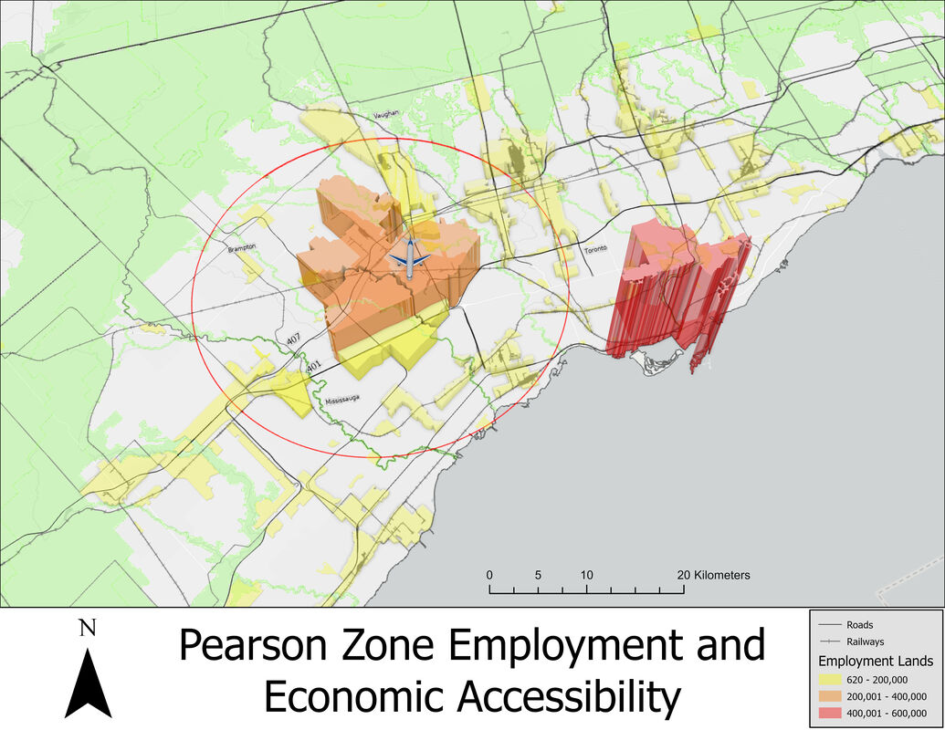 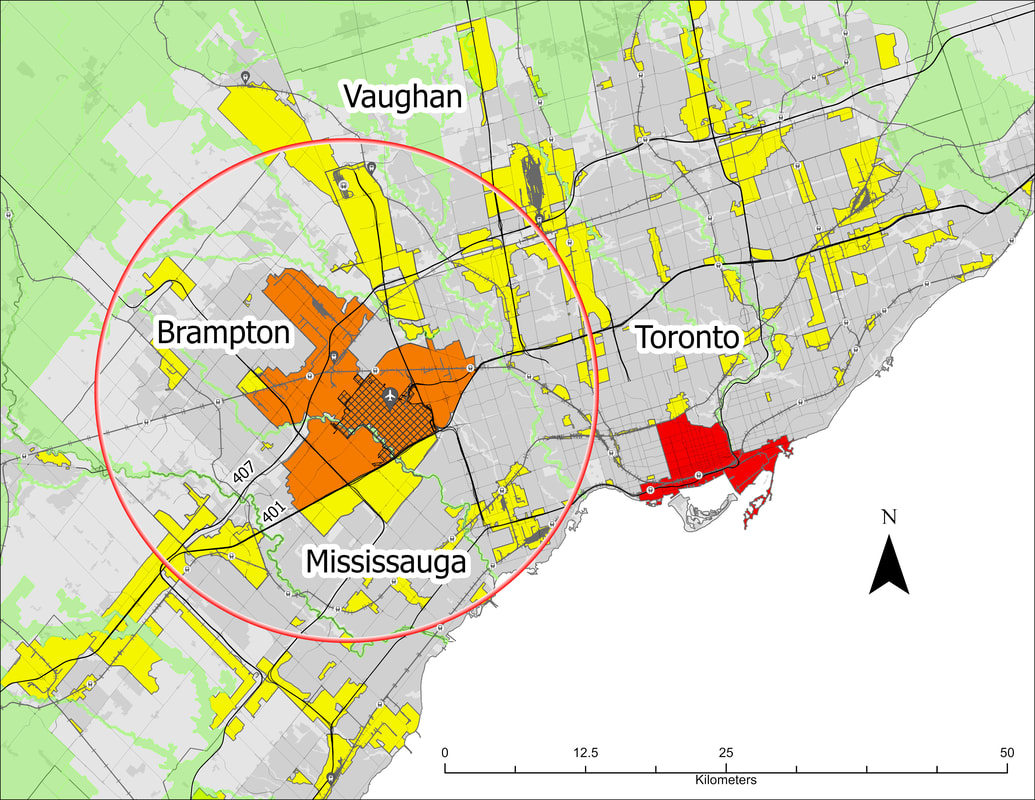 Data As a Digital Asset in Transit Planning and Economic Development Transit GTFS Feed data was web-scraped and used to assess transit route and transit stop activity in and around the Pearson Economic Zone (PEZ). These data are currently publicly available and accessible online. However, there are other forms of demographic data, both quantitative and qualitative, not so easily accessible to urban planners and data scientists, that would make for a much denser data landscape in economic development and urban planning. My theory is that blockchain-based, trustless and "permisionless" business models can help in building the incentive structure necessary to make data more decentralized and open for addressing our everyday challenges. This will also lead to the increase in geospatial data literacy and importance amongst the average person in the future by rewarding individual data providers for quality data instead of big tech aggregators. These innovative strategies can help to address the spatial pain points and bottlenecks causing economic uncertainty and lag in our Region. This will also pave the way for the Region's next generation of business development. The Application and Development of Spatial in Digital Assets for Everyday Truth Verification With the economy becoming more and more incorporated with the digital economy, it leaves room for the application of decentralized and trustless technology when connecting the economy with a dependence on digital and cloud-based IoT technology. With a spatial tracking of supply chains and removing of regulatory red tape to improve economic development, the applications of blockchain and smart contract programming into planning applications and supply chain management definitely deserves a closer look at its benefits and advantages to businesses.
I aim to promote geospatial literacy and data-driven initiatives focused on economic development and technological innovation in and around the Pearson Economic Zone. I wish to explore the role digital assets and data ownership can play in a digitally centric economy and discuss the details of our initiatives in the Pearson Economic Zone to learn new research techniques from experts and stakeholders in the field. I would love to hear from more enthusiasts in the field looking to share ideas for innovation in the zone. Feel free to connect with me by clicking on my contact card below. Cheers!
0 Comments
Leave a Reply. |
Archives
June 2023

|


 RSS Feed
